
How to geolocate your assets with GPS and Wi-Fi while extending battery life by years
There is an insatiable demand for tracking objects with small, battery-powered Internet of Things (IoT) devices. It’s a demand that was recently exacerbated by the supply chain disruption during COVID-19, says Maria Kalama, business development director, Lacuna Space.
It still remains somewhat untapped though as tracking devices using global navigation satellite systems (GNSS) like GPS or Galileo alone, have some limitations: high power consumption due to the GPS chip, which also does not work indoors or well in cities. In areas with poor network coverage the trace is also lost as devices cannot report location. An estimated 40% of organisations that have deployed asset tracking solutions have experienced connectivity problems.
The opportunity
Industrial applications accessing GNSS are mostly used for tracking vehicles and goods from the point of origin to the point of consumption, in sectors such as food and beverage, pharmaceuticals and industrial manufacturing. IoT analytics estimate that by 2025 there will be over 600 million tracking units using LPWAN (low power wide area network) technologies, with an expected global asset tracking market worth US$36.3 billion (€30.8 billion).
A Research and Markets study last year found that sensor-enabled smart tags remain a growing trend with 84% of respondents using sensors other than GPS in their asset tracking devices. The increased amount of electronics increases functionality but also device complexity. The report also revealed that respondents were least satisfied with battery lifetime and cost.
Slashing cost, extending asset management everywhere
Semtech Corporation, has recently released the LoRa Edge solution, which has been shown to slash power consumption, while being able to locate a device indoors. This is done by integrating a long-range LoRa transceiver, a GNSS satellite scanner and a passive Wi-Fi AP MAC address scanner into a single chip: the LR1110. That move also simplifies device complexity and reduces the cost of materials. Trials by our device partners IRNAS have shown an increase in battery life by several years, reducing the time, effort and cost of replacing batteries for the end customer.
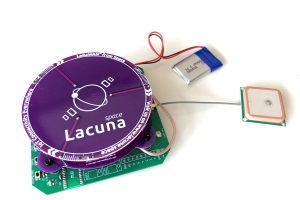
Of course, every chip needs a gadget or device to be useful. Lacuna Space, a provider for connectivity using satellites, has produced the first working IoT device to extend the tracking capabilities of LoRa Edge everywhere. Using satellites, even the most remote areas with no other network coverage or infrastructure can be covered. Lacuna Space is now working with its device partners to produce off-the-shelf “space ready” asset management trackers using LoRa Edge.
How it works

Maria Kalama
First, we have to look at the problems with the current set-up. For a device to know where it is using GPS, it has to receive several pieces of information for an extended duration from several GPS satellites. These pieces of information are transmitted from several satellites, over several channels and at a very low connection speed of 50 bits per second. The entire process can take up to 12 minutes and the device cannot enter a sleep state, thus consuming battery.
Using GNSS and Wi-Fi scanning through, the IoT device reduces the amount of information it receives from positioning satellites, which now takes less time and lets the device enter its sleep state for most of the time, thus saving battery power. By accessing the global navigational satellite systems GPS (USA) and BeiDou (China) for outdoors as well as Wi-Fi for indoor and inner-city applications, the IoT device can geolocate everywhere. The device sends a message with this reduced information from GNSS satellites and/or Wi-Fi to a cloud server, which then determines the location and can forward the information to wherever it is needed.
Combining LoRaWAN and satellites
To communicate the Lacuna device uses LoRaWAN (long-range wide area network). Using the LoRa (long range) technology either over satellite or a terrestrial LoRaWAN network, the device can also be integrated with existing network infrastructure – a unique feature amongst all other satellite IoT systems.
Combining IoT connectivity and geolocation via satellites, allows the device to provide positioning information every few hours wherever the tracked object is, bringing a huge financial benefit to asset tracking companies and extending the range of applications for them.
The author is Maria Kalama, business development director, Lacuna Space.
Comment on this article below or via Twitter @IoTGN